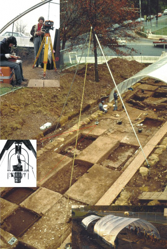
View of Raritan Landing 1979. All-weather emergency rescue excavation of EPA impact corridor through the early 18th century port of Raritan Landing, showing derivation of Whittlesey Bipod system to quickly record stereo and photo-mosaic overhead mages of buried 18th century living surfaces and foundation walls. Each camera set-up provided 15 x 15 ft image coverage. Tilting the rope supported bipod five to ten degrees to the side of the center point produced a continusious record of, metrically accurate, overlapping 30 to 60 degree stereo pairs and photo-mosaic coverage of the excavation corridor.
Inset at upper left shows first computer Electronic Distance meter (EDM) measurment and data collection equipment - capable of measuring only angle and distance, the data and subsequent coordinates had to be initially entered by hand. By end of project, small portable computers were interfaced and programemd to automatically convert the field readings. (See Grossman 1980, 2003, 2007b).
Inset at upper left shows first computer Electronic Distance meter (EDM) measurment and data collection equipment - capable of measuring only angle and distance, the data and subsequent coordinates had to be initially entered by hand. By end of project, small portable computers were interfaced and programemd to automatically convert the field readings. (See Grossman 1980, 2003, 2007b).
STEREOSCOPIC OVERHEAD PHOTOGRAMMETRY - Raritan Landing - 1979.
[Raritan Landing -1979] [Broad St. - 1984] [Fort Edward - 1986] [Loiza - 1987]
[Superfund at West Point Foundry -1989-1995] [Early LIDAR in Albany-1999] [Meadowlands GIS Plan - 1992 - 2006] [Mitigation Plan - Furnace Falls 2002 ]
[Furnace Dalls - Color LIDAR -2004]
[Superfund at West Point Foundry -1989-1995] [Early LIDAR in Albany-1999] [Meadowlands GIS Plan - 1992 - 2006] [Mitigation Plan - Furnace Falls 2002 ]
[Furnace Dalls - Color LIDAR -2004]