THEMES IN APPLIED GEOSPATIAL TECHNOLOGY
High precision3D Remote Terrestrial Recording Strategies
All-Weather Emergency Field & Lab. Deployments
Announcements
Home
Videos & Slideshows
Contact
Projects
Raritan Landing, NJ - 1979-82
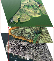
Broad St., NYC-Dutch West Indian Company 1984-85
Fort Edward, NY - 1986-87
Loiza, PR - 1987-88
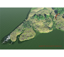
Meadowlands, NJ -1992 -94 & 2006
West Point Foundry, NY-1989-95
Albany, NY - 1999
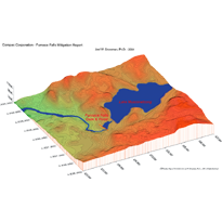
Furnace Falls, NJ-Mitigation Plan - 2002
Furnace Falls, NJ - Lidar Mitigation 2003-04
Biography
Publications
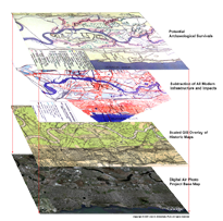
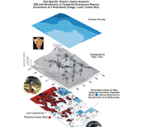
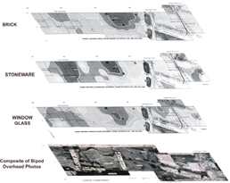
Historic GIS Impact Analysis
Concurrent, Real-time Data Control, Stabilization, Decontamination, Evaluation & Feedback
Dual and Single Camera
Photogrammetry
Laser-Radar (LIDAR) scanning
3D Geospatial Planning and Evaluation Strategies for Buried, Submerged and Contaminated Landscapes
Toxic and Hazardous Environments
PROJECTS
[
Raritan Landing
]
[
Broad st.
]
[
West Point Foundry
]
[
Furnace Falls-Lidar
]
[
Raritan Landing
]
[
Fort Edward
]
[
Loiza
]
[
West Point Foundry
]
[
Raritan Landing
]
[
Broad st.
]
[
Fort Edward
]
[
Loiza
]
[
Meadowlands
]
[
West Point Foundry
]
[
Furnace Falls Mit. Plan
]
[
Raritan Landing
]
[
Broad st.
]
[
Fort Edward
]
[
Loiza
]
[
West Point Foundry
]
[
Albany
]
[
Furnace Falls-Lidar
]
Computer Transit Systems
3D Paleo-Environmental Reconstruction
3DNYC,
3DNJ
PURPOSE
A Digital Qualifications Package
A Multi-media Platorm for 3D and Animation
A Vehicle for Low-cost Dissemination & Participation
To Demonstrate the Feasability of High Caliber Rescue Archaeology in Dangerous Environments
To Underscore the Importance of Archaeologically-controlled Environmental Data to Issues of Climate Change and Sea Level rise.
Non-Random Geophysical Survey & Mapping
Conductivity & Magnetics
Ground Penetrating Radar (GPR)
&
3D Sidescan Sonar
[
Raritan Landing
]
[
Broad st.
]
[
Fort Edward
]
[
Loiza
]
[
West Point Foundry
]
[
Furnace Falls Winter Lidar
]
Technologies
CONTENTS
NJ Meadowlands,
Lower Manhattan
Un-interrupted winter operations
Site Map